Top 10 Creepiest Things Discovered By Space Satellites
#10: The Gobi Desert Structure
In late 2011, a weird structure was discovered via Google Maps in China’s Gobi Desert. The “structure” looked like little more than white scribbles in the dust, without any form of order or pattern. Media outlets were quick to put out theories, with guesses ranging from street maps to some form of alien communication. The most plausible explanation, however, is far more grounded - well, as grounded as space can be. A technician working at the Mars Space Flight Facility named Jonathon Hill claims that the massive lines are used to calibrate spy satellites. By focusing on the grid and its pattern, the satellites can properly orient themselves while in orbit.
#9: Sandy Island
We all love a good ghost story. So how about one involving a ghost island? An island roughly the size of Manhattan near New Caledonia has been included on nautical charts since the 19th century, and even appeared on Google Earth as a smudgy black pixel. However, Australian scientists studying plate tectonics traversed the area in 2012 and discovered that the island...didn’t exist. [broll: X-Files music] It’s likely that the island never existed in the first place, and was just a giant pumice raft observed in the late 19th century. As Dr. Maria Seton of the University of Sydney declares, “During the conversion from hard-copy charts to digital formats the 'Sandy Island' error was entrenched.”
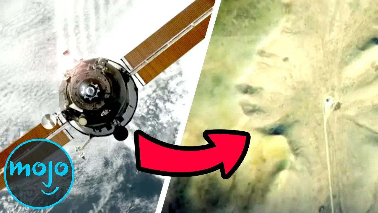
#8: Desert Lips
Located near the village of Arawala in Sudan is what appears to be a giant pair of lips embedded in the desert floor. Discovered on Google Maps, the “lips” make for an unsettling image. They’ve spawned numerous conspiracy theories (many of which were made in jest). Some think it’s a UFO, while a more outlandish theory claims that it houses a black hole - so long as the Earth’s mouth stays closed, we are safe. Of course, it could also just be a unique hill formation composed of raised sand and a row of trees … but that would just be boring!
#7: Trementina Base
As weird as Scientology is, we must admit that they have a flair for the dramatic. In 2005, aerial photographs showed unique signs in the desert of New Mexico. The signs are composed of two diamonds within overlapping circles. Seen from satellites, they look even weirder. This was identified as the symbol of the Church of Spiritual Technology, the nonprofit that owns the collective works of Scientology founder L. Ron Hubbard. The desert site, known as Trementina Base, is used to house the original Scientology texts; the writings and recordings are reportedly entombed within titanium caskets buried within the site’s underground vaults. And the symbols? According to BBC Panorama reporter John Sweeney, they’re to help returning Scientologists find Hubbard’s work from space after a future Armageddon.
#6: “Secret Military Base”
For this entry, we return to the deserts of China. An ex-CIA analyst found structures near Kashgar and went to Wired.com to report his findings. Speculation immediately ballooned, with many assuming that the “structures” were part of a secret military installation. But turns out, it’s not a military installation or even a secret. According to technologist Stefan Geens, it’s an up-and-coming industrial complex composed of factories and warehouses. Not only had China openly announced its plans to build there, but numerous construction vehicles can also be spotted in the satellite images. Way to ruin out suspicions that this was China’s Area 51!
#5: Shipwreck
There’s something inexplicably unsettling about looking at a shipwreck on Google Earth. Maybe it’s the unnatural aspect of it - seeing man made product in the middle of a gorgeous reef. A Bolivian cargo ferry named the S.S. Jassim ran aground and sank in the Wingate Reef of the Red Sea, located just to the east of Port Sudan. Satellite images showed the massive white ship lying on its side in the middle of the blue green reef, making for quite a shocking and weirdly creepy image. Unfortunately, that striking image can no longer be found on Google Earth, as the ship now appears as little more than a blurry brown blob.
#4: Abandoned Missile Launch Sites
Proposed by Bell Laboratories in 1945, Project Nike outfitted various sites with anti-aircraft missiles called Nike Ajax. While most of these missile sites were eventually abandoned and converted, some evidence of their existence remains in cities across America. These include Bay in Anchorage (which has since been overtaken by nature), LA-43 in White Point Park, HM-69 in Everglades National Park, and C-32 in Porter, Indiana (which is now surrounded by a subdivision). They look like little more than barren parking lots now, but it’s interesting, and a little creepy, knowing what was once housed there.
#3: Davis-Monthan Air Force Base
Have you ever wondered what the military does with all its decommissioned aircraft? Your answer lies in the Davis-Monthan Air Force Base, located in southeast Tucson. Found within the base is the 309th Aerospace Maintenance and Regeneration Group - or, more simply, The Boneyard. This location houses all of the US government’s out-of-service aircraft and ballistic missiles, resulting in rows upon rows upon rows of military vehicles; roughly 4,000. It’s quite a sight, indeed. The location was chosen for its lack of humidity, which prevents corrosion. The Boneyard has been featured in numerous pieces of pop culture, including the music video for Tom Petty’s “Learning to Fly.”
#2: Iraq’s Lake of Blood
Located in the northeast of Baghdad is a mysterious body of water with a distinct blood red color. It’s known as Lago Vermelho, and the source of the color remains a mystery. Numerous conspiracy theories have been put forth (like blood from a nearby slaughterhouse), but the likeliest explanation is either kelp blooms, salt, or bacteria turning the water red. It may also be an optical illusion from the satellite imagery itself. Many Google reviews report that the water is not actually red, even though it appears as such on Google Maps and Google Earth. Some report that it was “cleaned,” and others simply state that it’s “not red” without further explanation.
Before we unveil our top pick, here are a few honorable mentions.
Prehistoric “Wheels”
Geometric Shapes Found in Jordan's Azraq Oasis Could Be 8,500 Years Old
Mountain Peak
The Peak of Kangtega in Nepal Has Been Blacked Out
The Badlands Guardian
A Geomorphological Feature Resembling a Human Head
#1: Pentagram
Conspiracy theorists were delighted to find a pentagram etched into the grounds of rural Kazakhstan. Located on the southern shore of the Upper Tobol Reservoir, the creepy pentagram astounded conspiracy theorists and Google Earth lovers alike. It’s located near the city of Lisakovsk and can now be found on Google under the name “Lisakovsk Pentagram.” An archaeologist who works in the area named Emma Usmanova told LiveScience that the “pentagram” is just “the outline of a park made in the form of a star,” as stars were popular figures in the Soviet Union (to which Kazakhstan once belonged). Sorry guys, no devil worshipping here. Just a boring old park … allegedly ...
